Centro MTB Alanís. Alanís - Vía verde San Nicolás
Mountainbike


- Moeilijkheid
-
medium
- Waardering
-
- Route
-
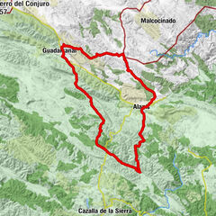
Alanís (673 m)0,3 kmCascadas del Hueznar18,2 kmLa Plaza19,7 kmSan Nicolás del Puerto (576 m)19,9 kmPosada del Peregrino20,1 kmAlanís (673 m)28,8 km
- Maximale hoogte
- 702 m
- Bestemming
-
Alanís
- Hoogteprofiel
-
 © outdooractive.com


- Auteur
-
De rondleiding Centro MTB Alanís. Alanís - Vía verde San Nicolás wordt gebruikt door outdooractive.com op.
GPS Downloads


Algemene info
Flora