Von Mittenwald auf die Brunnsteinhütte

Logo Von Mittenwald auf die Brunnsteinhütte
Toerdatums
7,31km
908 - 1.513m
Afstand
720hm
127hm
Opstijging
03:00h
 
Duur
Korte beschrijving

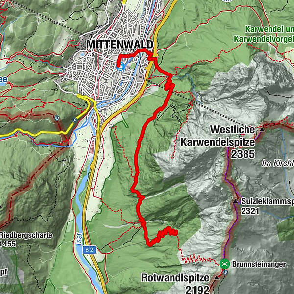
Durch schattigen Wald geht es von Mittenwald zur Brunnsteinhütte.

Moeilijkheid
medium
Waardering
Techniek
Conditie
Landschap
Belevenis
Route
Mittenwald (914 m)
Mittenwald
0,2 km
Brunnsteinhütte (1.560 m)
7,2 km

Maximale hoogte
1.513 m
Bestemming

Brunnsteinhütte

Hoogteprofiel
© outdooractive.com

Auteur
De rondleiding Von Mittenwald auf die Brunnsteinhütte wordt gebruikt door outdooractive.com op.

Algemene beoordeling

5

0

%

4

0

%

3

0

%

2

0

%

1

0

%

Fout
Er is een fout opgetreden. Probeer het opnieuw.
Bedankt voor uw beoordeling

Waardering is verwijderd

GPS Downloads
  • GPX GPS Exchange Format (XML)
  • KML Google Earth, Google Maps
QR Downloadcodes voor mobiele telefoons

Algemene info

Verfrissingsstop
Meer rondleidingen in de regio's

Populaire rondleidingen in de omgeving

Hinterriss - Eng - Falkenhütte

medium Wandelen
6,88km | 779hm | 04:30h

Wank

medium Wandelen
12,7km | 922hm | 04:42h

"Königstour" über die Gipfel

Wandelen
4,52km | 322hm | 04:00h