Toerdatums
9,84km
1.254
- 1.526m
407hm
402hm
02:37h

- Korte beschrijving
-
Sportlicher Aufstieg und dann wunderschönes Panorama
- Moeilijkheid
-
medium
- Waardering
-
- Route
-
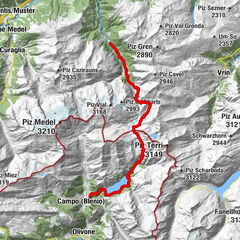
Vignogn (1.239 m)ustria crestas0,1 kmVella5,5 kmRumein (1.199 m)6,9 kmVattiz (1.246 m)7,6 kmDavos Munts Seecafé8,0 kmustria crestas9,5 kmVignogn (1.239 m)9,8 km
- Beste seizoen
-
janfebmrtaprmeijunjulaugsepoktnovdec
- Maximale hoogte
- 1.526 m
GPS Downloads


Meer rondleidingen in de regio's
-
Glarnerland
1972
-
Lumnezia
612
-
Vignogn / Lumnezia
194