Hike across Liechtenstein in 2 days, second stage

Wandelen


- Korte beschrijving
-
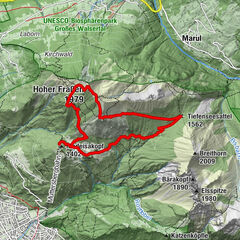
The 2nd stage leads from Steg over the Goldlochspitz into the rugged Naaf Valley. You can take a break or spend the night at the idyllic Pfälzer hut. The final section then leads via the Malbuner Täli to the mountain village of Malbun.
- Moeilijkheid
-
zwaar
- Waardering
-
- Route
-
Chrüppel (1.706 m)1,9 kmKolm (1.993 m)4,3 kmGoldlochspitz (2.110 m)5,2 kmGapfahl-Obersäss (1.879 m)6,6 kmPfälzerhütte12,0 kmMalbuner Stuba17,5 kmRestaurant Walserhof17,6 kmRestaurant Gitzihöll17,6 kmMalbun17,8 km
- Beste seizoen
-
janfebmrtaprmeijunjulaugsepoktnovdec
- Maximale hoogte
- 2.104 m
- Bestemming
-
Zentrum Malbun
- Hoogteprofiel
-
 © outdooractive.com


- Auteur
-
De rondleiding Hike across Liechtenstein in 2 days, second stage wordt gebruikt door outdooractive.com op.
GPS Downloads


Algemene info
Verfrissingsstop
Flora
Veelbelovend
Meer rondleidingen in de regio's
-
Heidiland
2208
-
Liechtenstein
1291
-
Malbun
308