© Donau Niederösterreich Tourismus, Steve Haider

© Donau Niederösterreich - Tourismusbüro Carnuntum-Marchfeld - Donau Niederösterreich, Robert Herbst

© Donau Niederösterreich Tourismus, Steve Haider

© Donau Niederösterreich - Tourismusbüro Carnuntum-Marchfeld - Donau Niederösterreich, Robert Herbst
Toerdatums
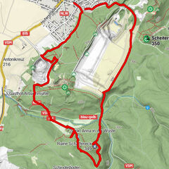
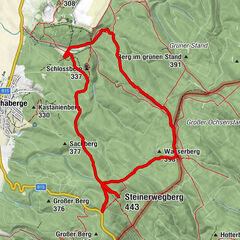
11,93km
165
- 225m
138hm
135hm
03:15h


- Korte beschrijving
-
TOP-Wanderweg: Weinwandern in drei Etappen - Rundweg Stixneusiedl - VIA.VINUM.
- Moeilijkheid
-
gemakkelijk
- Waardering
-
- Route
-
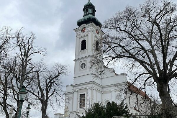
Pfarrkirche hll. Peter und PaulStixneusiedl0,0 kmHeuriger Hillinger0,1 kmHeuriger Flanitzer0,2 kmGaisberg (236 m)0,3 kmStixberg (230 m)0,3 kmGablerberg (217 m)2,9 kmArbesthal4,4 kmAutogrill7,1 kmStixneusiedl11,8 kmPfarrkirche hll. Peter und Paul11,8 km
- Beste seizoen
-
janfebmrtaprmeijunjulaugsepoktnovdec
- Maximale hoogte
- 225 m
- Bestemming
-
Kellergasse Stixneusiedl bzw. Bahnhof Sarasdorf
- Hoogteprofiel
-


- Auteur
-
De rondleiding VIA.VINUM. - Rundweg Stixneusiedl wordt gebruikt door outdooractive.com op.
GPS Downloads


Meer rondleidingen in de regio's