Toerdatums
19,9km
463
- 1.706m
1.415hm
1.426hm
08:00h

- Korte beschrijving
-
Höhenrundweg
- Moeilijkheid
-
medium
- Waardering
-
- Startpunt
-
Bahnhof Bad Ischl
- Route
-
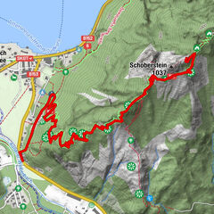
Bad Ischl0,1 kmNocken Toni3,4 kmKreutern3,5 kmBankerl Walkerskogel7,1 kmWalkerskogel (1.243 m)7,1 kmGartenzinken (1.557 m)7,7 kmMitterzinken (1.702 m)9,0 kmLeonsberg (1.745 m)9,5 kmGspranggupf (1.368 m)12,7 kmHohenzoller waterfall15,9 kmMaria Heimsuchung16,9 kmSt. Nikolaus19,5 kmBad Ischl19,6 kmBad Ischl19,8 km
- Beste seizoen
-
janfebmrtaprmeijunjulaugsepoktnovdec
- Maximale hoogte
- 1.706 m
- Bestemming
-
Bahnhof Bad Ischl
- Rust/Retraite
-
Nur in Bad Ischl. Keine am Berg! Kein Wasser am Berg!
- Bron
- Freizeitsportler
GPS Downloads


Condities van het pad
Asfalt
Steenslag
Weide
Bos
Rots
Moeilijk
Meer rondleidingen in de regio's
-
Salzkammergut Oberösterreich
3081
-
Bad Ischl
1646
-
Katrin-Alm
418