Tschigat (3,000 m) from the Leiter Alm mountain hut

Wandelen

Toerdatums
17,74km
1.478
- 2.959m
1.454hm
1.434hm
09:00h

- Korte beschrijving
-
The Tschigat is a striking peak in the Texel Group. The pyramid formed from gneiss offers a magnificent view of many mountain peaks. The tour to the Tschigat is not just a hike, but a real mountain tour with easy climbing passages (grade 2) in exposed terrain. Experience, a good physical condition, sure-footedness, a head for heights and stable mountain weather are prerequisites (dangerous with ice and snow).
- Moeilijkheid
-
zwaar
- Waardering
-
- Route
-
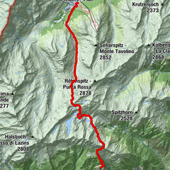
Leiteralm (1.550 m)0,2 kmKleiner Tschigat8,3 kmTschigat (2.999 m)8,4 kmSchutzhaus Hochgang (1.839 m)14,3 kmLeiteralm (1.550 m)17,4 km
- Beste seizoen
-
janfebmrtaprmeijunjulaugsepoktnovdec
- Maximale hoogte
- Leiteralm (2.959 m)
- Rust/Retraite
-
Restaurant Leiter Alm, Schutzhütte Hochgang, Haus Tschigat

GPS Downloads


Condities van het pad
Asfalt
Steenslag
Weide
Bos
Rots
Moeilijk
Meer rondleidingen in de regio's
-
Meraner Land
1736
-
Meran und Umgebung
756
-
Partschins - Rabland - Töll
247