© Eisacktal Marketing - Albert Gruber

- Korte beschrijving
-
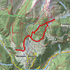
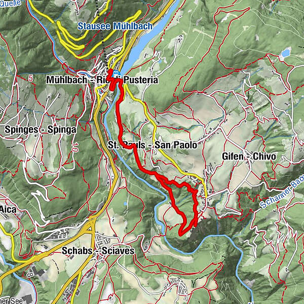
Passing the dam with its artificial lake along the road to Rodengo, this half-day tour traces the old service routes, past solitary farms and wooded stretches to Rodenegg Castle. Bus service between Rio di Pusteria – Rodengo.
- Route
-
Maria-Hilf-Kapelle0,0 kmMühlbach (775 m)0,2 kmSt. Pauls (860 m)2,2 kmAnrat2,3 kmGrasland2,3 kmKofelacker2,7 kmWeide3,2 kmDrei Plätze3,6 kmWaldackerle4,1 kmVill (885 m)5,0 kmRodeneck (882 m)5,3 kmGasplacker5,3 kmNeuraut6,1 kmRaut6,2 kmKofelacker6,3 kmGrasland6,8 kmAnrat6,8 kmSt. Pauls (860 m)6,9 kmMühlbach (775 m)8,8 kmMaria-Hilf-Kapelle9,1 km
- Maximale hoogte
- 860 m
- Bestemming
-
Rio di Pusteria|Mühlbach (777 m)
- Hoogteprofiel
-
 © outdooractive.com

- Auteur
-
De rondleiding From Rio di Pusteria|Mühlbach to Rodenegg Castle wordt gebruikt door outdooractive.com op.
GPS Downloads


Meer rondleidingen in de regio's
-
Brixen und Umgebung
1976
-
Gitschberg - Jochtal
672
-
Mühlbach
191