
- Korte beschrijving
-
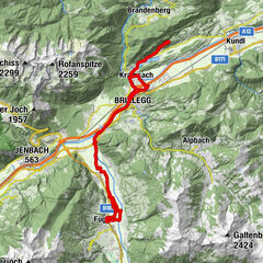
Day 3 – difficult:
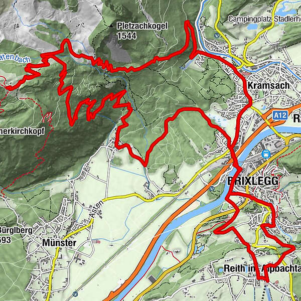
from Reith to Brixlegg – crossing the Montanwerk bridge to Kramsach/Hagau and via the route no. 357 to the Sonnwendjochbergbahn (defunct chairlift) – Kaltwasserbründl – Hergottstein – turn-off Pletzachalm – Bayreuther Hütte – descend via the mountain bike route no. 332 to Münster/Grünsbach and via Brixlegg back to Reith im Alpbachtal
- Moeilijkheid
-
zwaar
- Waardering
-
- Route
-
Reith im Alpbachtal (638 m)0,2 kmBischofsbrunn0,8 kmPestkapelle1,4 kmMehrn (560 m)2,0 kmBrixlegg2,7 kmWeng (526 m)2,9 kmHagau (517 m)4,0 kmAmerling4,9 kmKramsach5,0 kmLändbühel5,1 kmWittberg (526 m)5,6 kmEbnat5,9 kmLiftstüberl6,2 kmRadetzkyweg6,2 kmMariatal (533 m)6,9 kmBayreuther Hütte (1.560 m)14,4 kmGrünsbach (535 m)23,1 kmLandgasthof Astner23,2 kmHagau (517 m)26,4 kmBrixlegg27,0 kmWeng (526 m)27,6 kmPercha (568 m)28,7 kmSonnbichl29,5 kmDekanatspfarrkirche St. Petrus29,6 kmReith im Alpbachtal (638 m)29,8 km
- Beste seizoen
-
janfebmrtaprmeijunjulaugsepoktnovdec
- Maximale hoogte
- 1.563 m
- Bestemming
-
Reith im Alpbachtal
- Hoogteprofiel
-

- Auteur
-
De rondleiding Day 3 - Alpbachtal Mountainbike-Feeder Ride wordt gebruikt door outdooractive.com op.
GPS Downloads


Algemene info
Verfrissingsstop
Veelbelovend
Meer rondleidingen in de regio's
-
Alpbachtal
301
-
Kramsach
118