- Korte beschrijving
-
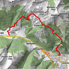
Hike for everyone with amazing views of the Tannheimer Tal, the Lechtal, the Reuttener Talkessel, the Zugspitze to the foothills of the Alps ...
- Moeilijkheid
-
medium
- Waardering
-
- Route
-
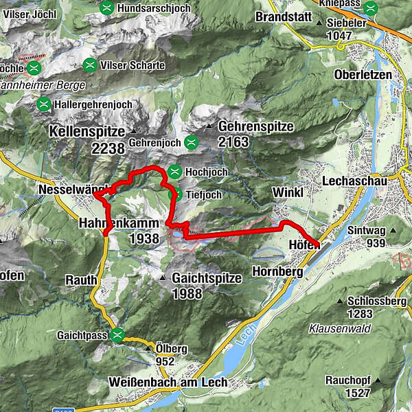
Nesselwängle (1.136 m)1,1 kmSchneetal Alm3,9 kmHahnenkamm (1.938 m)5,1 kmBergrestaurant Hahnenkamm6,0 kmPanoramarestaurant6,2 kmHöfener Alm6,4 kmCilli Hütte6,7 kmHahnenkammbahn Höfen8,7 kmHirschbachalm9,4 kmHöfen (868 m)9,7 km
- Beste seizoen
-
janfebmrtaprmeijunjulaugsepoktnovdec
- Maximale hoogte
- 1.908 m
- Bestemming
-
bottom station Hahnenkammbahn/bus stop Höfen
- Hoogteprofiel
-


- Auteur
-
De rondleiding Hahnenkamm wordt gebruikt door outdooractive.com op.
GPS Downloads


Algemene info
Verfrissingsstop
Flora
Fauna
Veelbelovend
Meer rondleidingen in de regio's
-
Allgäu
2368
-
Naturparkregion Reutte
1442
-
Höfen
583