Finale Enduro 2008
medium
Mountainbike 4,0
Navigeer naar
Navigeer naar
Ontvang deze tour op je mobiele telefoon
Kaart
Finale Enduro 2008
medium
Mountainbike
38,18 km
Scan de QR-code en start de navigatie in de bergfex app.
QR Code
Wandelen en spoorzoeken

Finale Enduro 2008

Afstand
38,18 km
Duur
05:30 h
Opstijging
1.156 hm
Zeespiegel
7 - 406 m
Track downloaden
Kaart
Finale Enduro 2008
medium
Mountainbike
38,18 km

The route takes you almost immediately to a junction, turn left into the first descent. At the following junction turn right, keep going straight until you reach another junction where you will pick up...


Beschrijving van de

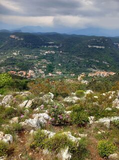
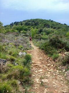
The route takes you almost immediately to a junction, turn left into the first descent. At the following junction turn right, keep going straight until you reach another junction where you will pick up the climb to the left and go uphill towards San Bernardino plateau. At the end of it, pick up the initial trail, this time following the main signposted track. At the junction near the barrier keep left and continue through the peculiar limestone outcrops until you reach Ciappo dei Ceci. Go back for about 100 m and descend to the right until you reach the rock walls. Near an abandoned campsite pick up the trail that goes uphill and leads to Orco, go across the village square and ride onto the dirt road that runs along the cemetery towards the descent to Boragni. Follow the directions to Magnone, then climb to the Manie plateau until you reach the panoramic spot of Bric dei Monti, from where the fourth descent of the day begins. From there on, you will reach quite a few junctions before you reach Monte near San Antonio church. Following the directions, via a mule-track, you will soon be at Finalpia. The route follows the racetrack of the FinalEnduro (first edition), organised in 2008, and leads you to discover panoramic spots such as Bric dei Crovi, Bric dei Monti or Punta Crena. Very impressive are the square Ciappo dei Ceci with its petroglyphs, the Monticello Dolmen and the caves, Grotte della Strapatente.

Route
Duomo di San Giovanni Battista
(8 m)
Gebedshuis
0,9 km
Finale Ligure
(5 m)
Stad
1,2 km
Chiesa di San Lorenzo
(365 m)
Gebedshuis
15,7 km
Bric dei Crovi
(386 m)
Top
27,4 km
Varigotti
(9 m)
Dorp
30,0 km
Chiesa di Sant'Antonio al Monte
(117 m)
Gebedshuis
36,7 km
Santuario di Santa Maria di Finalpia
(5 m)
Gebedshuis
37,7 km
Route
Kaart
Finale Enduro 2008
medium
Mountainbike
38,18 km
Finalpia
(5 m)
Buurt
0,2 km
Chiesa dei Neri
(6 m)
Gebedshuis
0,7 km
Duomo di San Giovanni Battista
(8 m)
Gebedshuis
0,9 km
Finalmarina
(3 m)
Buurt
0,9 km
Finale Ligure
(5 m)
Stad
1,2 km
San Bernardino
(241 m)
Buurt
4,4 km
Olirette
(256 m)
Corridor/terrein
13,7 km
Orco
(367 m)
Schikking
15,6 km
Chiesa di San Lorenzo
(365 m)
Gebedshuis
15,7 km
Nava
(291 m)
Corridor/terrein
17,1 km
Boragni
(182 m)
Schikking
18,3 km
Mesana
(191 m)
Corridor/terrein
20,3 km
Magnone
(270 m)
Dorp
22,8 km
Castelletto
(410 m)
Top
24,0 km
Bric dei Monti
(410 m)
Top
24,5 km
Bric dei Crovi
(386 m)
Top
27,4 km
Cian du Feru
(314 m)
Corridor/terrein
28,2 km
Termine
(307 m)
Corridor/terrein
28,4 km
Varigotti
(9 m)
Dorp
30,0 km
Isasco
(249 m)
Schikking
31,6 km
Torre Mendari
(295 m)
Corridor/terrein
32,1 km
Le Mànie
(288 m)
Schikking
33,4 km
Osteria della Briga
(280 m)
Restaurant
34,7 km
Chiesa di Sant'Antonio al Monte
(117 m)
Gebedshuis
36,7 km
Monte
(128 m)
Schikking
36,7 km
Finalpia
(5 m)
Buurt
37,7 km
Santuario di Santa Maria di Finalpia
(5 m)
Gebedshuis
37,7 km
Finale Ligure
(5 m)
Stad
38,0 km
Beschrijving van de

You can reach the start of the route from Finale Ligure following the directions to Ciappi trail.

Technologie
n.v.t.
Voorwaarde
4 / 6
Landschap
5 / 6
Ervaring
3 / 6
Het hele jaar door toegankelijk
Jan
Feb
Maa
Apr
Mei
Jun
Jul
Aug
Sep
Okt
Nov
Dec
Auteur
Geleverd door be active LIGURIA
De Finale Enduro 2008 rondleiding wordt verzorgd door outdooractive.com.
Logo
Deel tour
Kaart
Finale Enduro 2008
medium
Mountainbike
38,18 km
Fout
Er is een fout opgetreden. Probeer het opnieuw.
Aankomst informatie
Aankomst

Access by car: Exit the motorway at the tollbooth of Finale Ligure, then continue towards the town centre. info: Associazione Finale Outdoor Resort - riccardo.negro@finaleoutdoorresort.com

Openbaar vervoer

Shuttle Service: not available

Parkeren

Finale Ligure

Aanvullende informatie & tips
Aanvullende informatie

Classification: EN Difficulty: moderate Rideability +/- : 99% Water points: 4 Local Knowledge: www.finaleoutdoorresort.com

Taxaties
4,0
5
(0)
4
(1)
3
(0)
2
(0)
1
(0)
5
(0)
4
(1)
3
(0)
2
(0)
1
(0)
Schrijf een review

Beoordelingen helpen andere gebruikers bij het kiezen van hun volgende avontuur. Beoordeel alleen de tour, niet het weer of je tussendoortje.

Selecteer een van de sterren om de tour te beoordelen
Slechte tour
Zwakke tour
Middelmatige tour
Goede rondleiding
Uitstekende rondleiding
bergfex logo Inzicht krijgen Altijd live op locatie met meer dan 9.500 webcams. bergfex Als Pro-gebruiker kun je nu de bijbehorende webcams voor veel tours zien in de tours-app van. Zo kun je de actuele omstandigheden direct bekijken.
Wandelen en spoorzoeken

Wandelen en spoorzoeken

Wandelen en spoorzoeken
Meer dan 550.000 suggesties voor tochten, gedetailleerde kaarten en een intuïtieve routeplanner maken de app een must-have voor alle natuurliefhebbers.
Wandelen en spoorzoeken