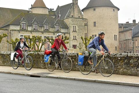
Creuse route: Bénévent-l’Abbaye > Royère de Vassivière
Moeilijkheidsgraad: 4
Over 400 km of marked routes await you to discover the Creuse from east to west and north to south!
This Creuse route will allow you to discover the remarkable—and often little-known—natural and cultural...
Over 400 km of marked routes await you to discover the Creuse from east to west and north to south!
This Creuse route will allow you to discover the remarkable—and often little-known—natural and cultural heritage of a department rich in remarkable and surprising sites!
From the Creuse painters’ valley to Lake Vassivière, passing through Aubusson, the Landes pond Nature Reserve, the medieval towns of La Souterraine, Bénévent l’Abbaye, Bourganeuf, or the abbey church of Chambon/Voueize and the spa town of Evaux les Bains, it is a countryside with ever-changing landscapes to discover along the small roads.
This stage begins at Bénévent-l’Abbaye, the only commune in Creuse to have obtained the “Petite Cité de Caractère©” label, then passing through Châtelus le Marcheix, a pretty village nestled in the gorges of the Thaurion, it heads to Bourganeuf, a medieval town from the 12th century with a unique history.
The rest of the route follows the southern link of the cycle route and will take you to Royère de Vassivière.

This 72 km stage is made for trained calves, you will encounter some elevation changes (1,203 meters) including two nice hills at the hamlets of Villemonteix and Saint Pardoux Morterolles.
The route starts on the West cycle route and ends on the southern link near Royère de Vassivière.
Haute-Vienne Link (15 km with 235 m elevation gain)
A 15 km link possibility with Haute-Vienne starting from the village of Châtelus le Marcheix passing through Saint Pierre Chérignat and Saint Martin Sainte Catherine
A well-maintained and well-equipped bike helps ensure your safety as well as that of other road users.
Before setting off:
Make sure the bike is in perfect mechanical condition, including tires and brakes Ensure the bike is properly adjusted to your body shape Wearing a helmet is strongly recommended Take a repair kit with you Remember that the highway code applies to cyclists at all times Never ride more than two abreast and move into a single file when traffic conditions require Respect other road users as you would want them to respect you Choose a route suited to your physical abilities Inform those around you of your itinerary Check the weather conditions A first aid kit is not essential but can be very useful Inform yourself and keep emergency phone numbers handy Respect the environment by not throwing food packaging onto the roadside If you need to return at dusk, make sure you can see and be seen
Emergency number: 112
4
Monts and Vallées Ouest Creuse Tourist Offices:
Welcome point of Bénévent-l’Abbaye
2 rue du Marché
23210 BENEVENT L’ABBAYE
Tel: + 33 (0)5 55 62 68 35
Tourist information office
31 Rue des Deux Ponts
23430 CHATELUS LE MARCHEIX
Tel: + 33 ()05 55 64 82 80
Lac de Vassivière Tourist Office
Lieu-dit Auphelle
87470 PEYRAT LE CHATEAU
Tel: + 33 (0)5 55 69 76 70
Creuse Sud Ouest Tourist Office
Welcome point of Bourganeuf
Place du champ de foire
23400 BOURGANEUF
Tel: + 33 (0)5 55 64 12 20
Not to be missed
Bénévent-l’Abbaye: The 12th century abbey church and the Scénovision, a show route where you discover the story of Marion, a young peasant woman from the 1900s. Bourganeuf: A medieval city, one of the first in Europe to be electrified in the 19th century with its impressive Zizim Tower. Saint Martin le Château: Jarrauds Waterfall Lake Vassivière: An ideal playground for water activities with its 30 km long lake shore path, sometimes the scene of epic Tour de France time trial stages.
Populaire rondleidingen in de buurt
Mis geen aanbiedingen en inspiratie voor je volgende vakantie
Uw e-mailadres is toegevoegd aan de mailinglijst.


